


General

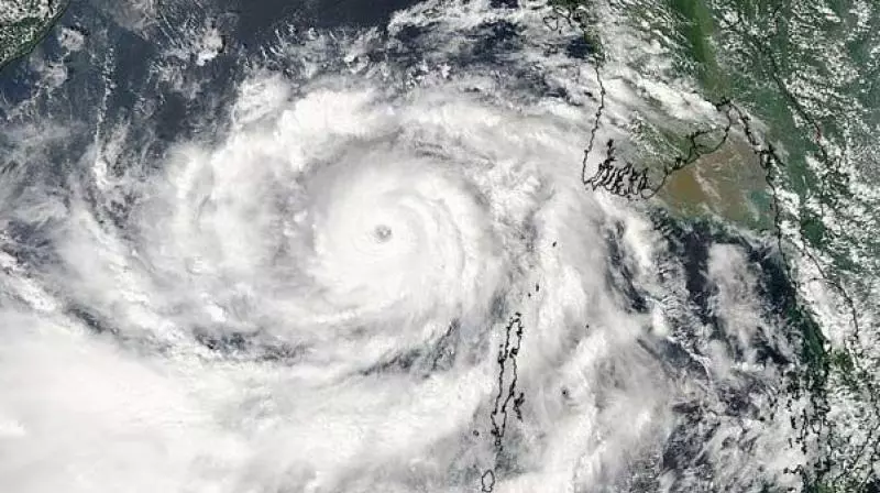
Cyclonic storm Senyar moved ashore along the Indonesian coastline on Wednesday morning, making landfall between 7:30 a.m. and 8:30 a.m. IST with sustained winds reaching 70 to 80 kmph and gusts touching 90 kmph, according to the IMD centre in Amaravati. The system, which was tracking west-southwest across the Strait of Malacca at nearly 13 kmph, crossed the coast near latitude 4.9°N in northeast Indonesia.
By the time it made landfall, Senyar was positioned over coastal regions of northeast Indonesia, roughly 80 km east of Kuta Makmur and about 280 km west of George Town in Malaysia.
The storm is currently located nearly 580 km southeast of Nancowry and around 730 km southeast of Car Nicobar in the Nicobar Islands. The IMD said the system is expected to maintain its cyclonic strength through early November 27 before changing direction toward the east and gradually weakening within the next 24 hours.
In the Bay of Bengal, a separate weather system is also developing. A well-marked low-pressure area lying over the southwest Bay of Bengal, southeast Sri Lanka, and the adjoining Equatorial Indian Ocean is forecast to intensify into a depression within a day. It is expected to move north-northwest, strengthening further as it nears the North Tamil Nadu and Puducherry coasts over the next 48 hours.
Beginning November 29 and continuing until December 1, isolated parts of south coastal Andhra Pradesh and Rayalaseema are likely to experience heavy to very heavy rainfall, along with thunderstorms and strong winds.
Temperatures recorded across Andhra Pradesh on Wednesday were as follows: Kalingapatnam (27.9°C), Visakhapatnam (29.2°C), Tuni (31.5°C), Kakinada (30.6°C), and Amaravati (31.5°C).


Comments (0)
No comments yet
Be the first to comment!